CSET Requirement 2.1 f: Describe the evidence for plate tectonics on the sea floor and on land.
Sea Floor: Fit of the Continents
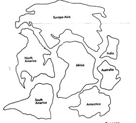
In 1915, Alfred Wegener proposed a hypothesis that suggested that Earth's continents once were part of a large super-continent called Pangea. Then about, 200 million years ago, the super-continent broke into pieces that drifted over the surface of Earth to their current positions. The fit of South America with Africa, fossil evidence, rock structures and ancient climates support this idea.
Puzzle Pieces: The idea that continents fit together like pieces of a jigsaw puzzle originated with improved world maps. However, Wagner's hypothesis was initially challenged because shorelines are continually modified due to erosion and good "fit" of continents were seen as unlikely. Another argument made was that fossil evidence showed that land areas had been uplifted (from the sea) or submerged in recent geological past. It was not until the 1960's when sonar technology was used to map the seafloor that Wegener's hypothesis gained support. A better approximation of the outer boundary of continents was perceived and called the continental shelf. It lies submerged off the coast of continents and gave a remarkable fit to the "puzzle pieces."
Puzzle Pieces: The idea that continents fit together like pieces of a jigsaw puzzle originated with improved world maps. However, Wagner's hypothesis was initially challenged because shorelines are continually modified due to erosion and good "fit" of continents were seen as unlikely. Another argument made was that fossil evidence showed that land areas had been uplifted (from the sea) or submerged in recent geological past. It was not until the 1960's when sonar technology was used to map the seafloor that Wegener's hypothesis gained support. A better approximation of the outer boundary of continents was perceived and called the continental shelf. It lies submerged off the coast of continents and gave a remarkable fit to the "puzzle pieces."
Land: Fossil Evidence

Wegener had merely asserted an idea which he thought improbable. He needed something else to solidify his own hypothesis and considered the fossil record. Some type of land connection was necessary to explain the existence of identical fossils on widely separated landmasses. The classic example is the Mesosauras, a presumably aquatic reptile whose fossil is limited to South America and Southern Africa (blue region on pic). Also cited for evidence of Pangea is the Glossopteris. This plant was known to be widely dispersed among Antarctica, Africa, Australia, India and South America (green region on pic). In this same way fossil remains of the Lystrosauros (brown region), Cygnognathus (orange region) helped support Pangea and consequently provide evidence for plate tectonics (used to explain land movement).
Land: Rock Types
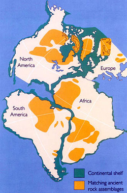
Wegener looked for other similarities among continents and now looked at rock types. If the continents were once together, the rocks found in a particular region on one continent should closely match in age and type with those of an adjacent continent. A good correlation between rocks found in northwestern Africa was made with rocks in eastern Brazil. In both regions, 550 million year old rocks lie adjacent to rocks dated at more than 2 billion years. More evidence to support the concept of continental drift (via plate tectonics) comes from several mountain belts that appear to end at one coastline only to reappear again on a landmass across the ocean. For example, the mountain belt that includes the Appalachians trends northeastward through the United States and disappears off the coast of Newfoundland. Mountains of comparable nature are found in Greenland and Northern Europe.
Paleomagnetism: Studies in rock magnetism set out to investigate ancient changes in Earth's magnetic field. If you have used a compass, or in general, you are aware that magnetic field has a north and south pole. Magnetic poles align closely, but are not exactly with geographic poles. Iron rich minerals cool and become magnetized in the direction parallel to the existing magnetic field and cone solidified, the magnetism will remain frozen in that position. These rocks formed in the past are said to "remember" the location of magnetic poles and are said to possess fossil magnetism. Using these rocks, a plot of the position of the magnetic pole revealed that during the past 500 million years, the position of the pole had gradually wandered from a location near Hawaii northward through Siberia and finally to its present location. This was clear evidence that either the magnetic poles had shifted through time (polar wandering) or that lava flows moved - in other words, the continents had shifted.
Paleomagnetism: Studies in rock magnetism set out to investigate ancient changes in Earth's magnetic field. If you have used a compass, or in general, you are aware that magnetic field has a north and south pole. Magnetic poles align closely, but are not exactly with geographic poles. Iron rich minerals cool and become magnetized in the direction parallel to the existing magnetic field and cone solidified, the magnetism will remain frozen in that position. These rocks formed in the past are said to "remember" the location of magnetic poles and are said to possess fossil magnetism. Using these rocks, a plot of the position of the magnetic pole revealed that during the past 500 million years, the position of the pole had gradually wandered from a location near Hawaii northward through Siberia and finally to its present location. This was clear evidence that either the magnetic poles had shifted through time (polar wandering) or that lava flows moved - in other words, the continents had shifted.
