CSET Requirement 2.2c: Explain the layered structure of the oceans, including the generation of horizontal and vertical ocean currents and the geographic distribution of marine organisms, and how properties of ocean water, such as temperature and salinity, are related to these phenomena.
Structure of the Oceans

Scientists have divided the ocean into five main layers. These layers, known as "zones", extend from the surface to the most extreme depths where light can no longer penetrate. These deep zones are where some of the most bizarre and fascinating creatures in the sea can be found. As we go deeper, the temperature drops and the pressure increases at an astounding rate. The diagram on the left lists each of these zones in order of depth.
Epipelagic Zone - The surface layer of the ocean is known as the epipelagic zone and extends from the surface to 200 meters (656 feet). It is also known as the sunlight zone because this is where most of the visible light exists. With light comes heat which is responsible for the wide range of temperatures that occur in this zone.
Mesopelagic Zone - Below the epipelagic zone is the mesopelagic zone, extending from 200 meters (656 feet) to 1000 meters (3281 feet). The mesopelagic zone is sometimes referred to as the twilight zone or the midwater zone. The light that penetrates to this depth is extremely faint. It is in this zone that we begin to see the twinkling lights of bio-luminescent creatures. A great diversity of strange and bizarre fishes can be found here.
Bathypelagic Zone - The next layer is called the bathypelagic zone. It is sometimes referred to as the midnight zone or the dark zone. This zone extends from 1000 meters (3281 feet) down to 4000 meters (13,124 feet). Here the only visible light is that produced by the creatures themselves. The water pressure at this depth is immense, reaching 5,850 pounds per square inch. In spite of the pressure, a surprisingly large number of creatures can be found here. Sperm whales can dive down to this level in search of food. Most of the animals that live at these depths are black or red in color due to the lack of light.
Abyssopelagic Zone - The next layer is called the abyssopelagic zone, also known as the abyssal zone or simply as the abyss. It extends from 4000 meters (13,124 feet) to 6000 meters (19,686 feet). The name comes from a Greek word meaning "no bottom". The water temperature is near freezing, and there is no light at all. Very few creatures can be found at these crushing depths. Most of these are invertebrates such as basket stars and tiny squids. Three-quarters of the ocean floor lies within this zone. The deepest fish ever discovered was found in the Puerto Rico Trench at a depth of 27,460 feet (8,372 meters).
Hadalpelagic Zone - Beyond the abyssopelagic zone lies the forbidding hadalpelagic zone. This layer extends from 6000 meters (19,686 feet) to the bottom of the deepest parts of the ocean. These areas are mostly found in deep water trenches and canyons. The deepest point in the ocean is located in the Mariana Trench off the coast of Japan at 35,797 feet (10,911 meters). The temperature of the water is just above freezing, and the pressure is an incredible eight tons per square inch. That is approximately the weight of 48 Boeing 747 jets. In spite of the pressure and temperature, life can still be found here. Invertebrates such as starfish and tube worms can thrive at these depths.
Ocean Currents

Let's review basic stuff here and recall how heat moves: radiation, conduction and convection. You learned that radiation allows heat to travel through space and conduction allows it to move from one solid to another through contact. Convection allows heat to travel through gas or liquids by movements of currents.
Water, like air, is a fluid that can carry heat as it moves from one place to another. Meteorologists have different terms for horizontal and vertical movement of fluids: movement in the vertical direction driven by buoyancy is called convection, and movement in the horizontal direction is called advection. Convection contributes, with radiation and conduction, to the movement of heat in the vertical direction. But advection is essentially the sole process by which heat moves laterally over the surface of the earth.
Water is about 1,000 times as dense as air, and, since the amount of thermal energy transported by a moving fluid is proportional to its density, a volume of water can transport about a thousand times as much heat as an equivalent volume of air.
The picture above shows global currents with direction, temperature and latitudinal location. Note the location of the Equator and the general direction of motion in the Northern and Southern Hemisphere. The Southern Hemisphere has major counterclockwise circulation gyres (large system of rotating current). The clockwise circulation patterns in the Northern Hemisphere include gyres in the North Atlantic and two cells in the North Pacific Ocean. At latitudes above 30N and below 30S, circulation patterns become more complicated due to interactions with continents and the Arctic Ocean. The Gulf Steam carries warm tropical water off the east coast of the US in a direct path toward Great Britain and the Scandinavian countries, giving these regions a far warmer climate than, say, Alaska which is at a comparable latitude. For example, the Davidson Current off the coast of California which travels counter-clockwise opposing the California Current (which has clockwise movement) during winter months. Related to this is an interesting consequence in that, in both hemispheres, the west coasts of continents generally have flow toward the Equator and east coasts have flow away from the Equator. Other factors being equal, this suggests that west coasts of continents will have slightly cooler water offshore compared to east coasts at the same latitude. In the US, the water off northern California is much colder than off New York, at the same latitude.
The Coriolis Effect

So what's responsible for the clockwise movement of gyres above the equator and it's counter movement down below the equator?
The rotation in the major ocean basins is driven by a combination of wind stress at the ocean surface and the Coriolis force due to the earth's rotation. The winds at the earth's surface are directed from east to west in at the Equator and generally west to east at the middle latitudes (30 to 60o north and south of the equator). The wind induces an ocean drift current generally in the same direction but rotated slightly, deflected by the Coriolis force to the right of the wind direction in the Northern Hemisphere and to the left of the wind in the Southern Hemisphere.
The effect of the Coriolis force can be visualized by considering the ocean circulation as seen from the North Pole as on the pic to the left. The earth rotates as shown by the top arrow. The law of conservation of momentum says that in the absence of forces, the momentum of an object does not change. Water (or air) that has a component of its velocity toward the Equator will be moving to positions at greater distance from the polar axis. Because of the rotation of the earth, the total speed of the water or air will increase (and violate the law of conservation of momentum) unless it moves in the direction opposite to the rotation, and follows a path that curves to the right. A parcel moving towards the axis of rotation (northward in the Northern Hemisphere) similarly will move in a clockwise direction. For flow south of the Equator, the same reasoning leads to the conclusion that rotation in the Southern Hemisphere is in the counterclockwise direction.
Temperature, Salinity and Density

Vertical motions in the ocean are driven by small differences in water density due to differences in salinity (salt content) and (or) differences in temperature. Increased salt content increases density of water, and generally cold water is more dense than warm water. Density goes up as temperature decreases. Salinity goes up and density increases. These two factors will play with density in different ways when put or mixed with different bodies of water.
The ocean does not have a uniform salinity. As ocean water flows toward the polar region from the Equator, it passes the subtropical high-pressure zones (latitudes 25 to 35 North and South) that have very little precipitation but intense solar radiation that promotes evaporation. (Southern California is at this zone, with notable arid conditions and strong condensation events such as fogs and June gloom). In regions where evaporation is high, the salt content of the remaining surface water increases, thereby increasing the density. In regions where precipitation is high, fresh-water rain will ride on top of the saline ocean water, because warm salt waters will be denser (heavier). Similarly melting ice in polar regions will be less dense than nearby ocean water of temperature because of its lower temperature and lack of salt.
These concepts of density dependence on temperature and salinity explain the linkage of surface water to the abyssal (deep ocean) circulation. In the North Atlantic ocean, water traveling northward at the surface passes through the subtropical high pressure zone and experiences a density increase due to evaporation. As it continues northward evaporation continues to increase the salinity and hence the density, but cooling due to heat loss to the atmosphere also contributes to increasing the density. Ultimately the density increases to the extent that massive subsidence is created to the north of Iceland. The subsidence region in the Southern Hemisphere is explained for the same reason, since warm water from the tropical Pacific has experienced both evaporation and cooling.
The vertical circulation caused by density differences due to differences in ocean temperature and salinity is called the thermohaline circulation. Horizontal global ocean circulation is driven by wind stress at the ocean surface (coriolis effect), but vertical mixing is largely due to the thermohaline circulation.
Geographic Distribution of Marine Organisms
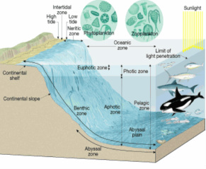
The geographic distribution of marine organisms depends on their responses to current, temperature, and physical barriers. In particular, their local distribution is affected by waves and tides, bottom composition, salinity, and depth. Marine biocycles are mainly divided into pelagic (open water) and benthic (bottom) cycles. Major communities recognized are the oceanic plankton and nekton biome in the open sea, and the coral reef biome.
Organisms that comprise the oceanic biome are widely distribution around the world, but may be divided into warm-water, Arctic, and Antarctic faunas. Coral reefs are found only in the tropics. The two biomes on the continental shelf subdivide into warm-water, temperate, Arctic, and Antarctic faunas as well as into more restricted regions and subregions. The warm-water faunas are richest in species, especially in the Indo-Malayan and West Indian subregions.
Marine plankton include a greater variety of forms than does fresh-water plankton, although rotifers are nearly absent and cladocerans are less important. Although abundance varies greatly from place to place and from season to season, plankton is generally much more numerous in coastal waters than in the open sea. They also possess various unique mechanisms for flotation. Diel movements between the surface at night and greater depths during the day are pronounced.
Mollusks (squids), fishes, birds, and mammals constitute the nekton. The taxonomic composition of the fish fauna varies with depth. Bioluminescence is exceptionally well developed among deep-sea nekton and benthos.
Marine benthos includes a great variety of sessile, creeping, and burrowing forms. It is very abundant in the littoral zone, and decreases in numbers with depth, although individuals are found in the deepest ocean trenches. There is considerable difference in the life-form and species composition of benthos occurring on rocky shores as compared to those found in sand and mud bottoms. Zonation of species is more prominent on rocky than on depositing shores. Succession and dominance occurs in some situations, but is less important than in terrestrial communities. Coral reefs have many special features, but are now exposed to damage by a species of starfish in the Pacific and Indian Oceans.
Food chains in the sea are similar to those in fresh water but the number of links and species composition varies in different communities. Productivity is especially high in regions where upwelling and turbulence bring nutrients from deeper levels up to the surface. The three greatbiocycles of ocean, fresh-water, and land come into contact around the margins of the seas. The succession from the ocean to land is abrupt and from the ocean to fresh water through estuaries only slightly less so.
